My primary interest is in sea-level rise associated with climate change, and the impact it will have on the coast (for example, in dramatically increasing the frequency of flooding events from the ocean). A subsidiary interest (with a collaborator, Ben Galton-Fenzi) involves using computer models to simulate the way in which climate change will alter the ocean circulation under ice shelves.
Previous interests have been the development of software for the simulation of the hydrodynamics and dispersive properties of coastal marine systems.
Much of my work is of an applied nature and has been funded by both government and commercial organisations.
Click here for a short CV, here for a long CV, here for a list of published papers, here for a list of published conference proceedings or here for a list of unpublished technical reports.
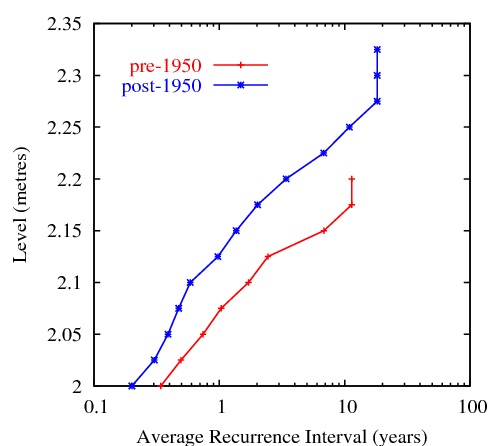
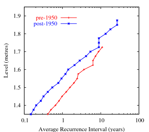
The following figures show the average recurrence intervals for Fort Denison (Sydney, top) and Fremantle (bottom) for roughly 50-year periods before and after 1950 (from Church et al., 2006). The figures show that events that occur on annual to decadal timescales increased their frequency of occurrence by a factor of about three during the 20th century, mainly as a result of sea-level rise.
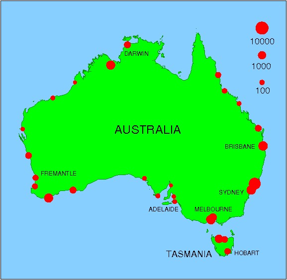
The figure below indicates the factor by which the frequency of coastal flooding events will increase under conditions of a 0.5 metre sea-level rise. For example, at Sydney, the frequency of flooding events will increase by a factor of about 1000. The average factor for Australia is around 300, meaning that events which presently happen annually will occur every day, and events which presently have a 100-year return period will occur several times a year. For more information, see Church et al., 2008.
Further misinformation concerning sea-level rise at Tuvalu (Eschenbach, 2004, Energy & Environment, Vol. 15, No. 3, pp. 527-543) was countered by Hunter (2004).
Church, et al. (2006) described analyses of tide-gauge and satellite-altimeter data for the Pacific and Indian Oceans, showing that sea level has clearly risen in these regions since 1950. In particular, no evidence was found for the fall in sea level at the Maldives postulated by Morner et al. (2004, Global and Planetary Change 40, 177-182).
In 2007, I participated in a technical review of the South Pacific Sea Level and Climate Monitoring Project (SPSLCMP) for AusAID, the results being reported by Sandford et al. (2007).
In late 2008, I visited Takuu Atoll (or the Mortlock Islands) with Scott Smithers (James Cook University) and film-makers Briar March and Lyn Collie. Briar and Lyn were making a documentary on the effects of sea-level rise on the atoll, and Scott and I joined them to provide scientific advice and to do our own research. The resultant film, There Once was an Island, won first prize at the FIFO festival in Tahiti in February 2010. Some of our early results were presented at the 9th International Conference on Southern Hemisphere Meteorology and Oceanography in February, 2009.
I have been involved in applying hydrodynamic models such as the Princeton Ocean Model (POM) and the Regional Ocean Modeling System (ROMS) to the ocean cavity under ice shelves. Hemer,et al. (2006) simulated the tides under the Amery Ice Shelf, optimising the shape of the southern part of the cavity (which is otherwise poorly known) by matching the simulations to tidal observations. Subsequently, Galton-Fenzi,et al. (2008) used an improved model and new observational data to further refine the topography of the Amery cavity. For further information, see Ben Galton-Fenzi's web site.
This study was a collaboration between myself, CSIRO, the Southampton Oceanography Centre (David Pugh), the University of Canberra (Peter Morgan), the University of Tasmania (Richard Coleman) and the Tasmanian Department of Environment and Land Management (Nick Bowden). Images of Port Arthur and the benchmark are courtesy of Bruce Miller, Hobart.
For an early description, you may read an article in The Tasmanian Surveyor . The results of our study were published as:
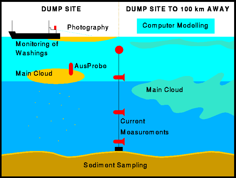
The investigation involved a number of tasks, which fell into three broad categories:
 Click here for a larger schematic.
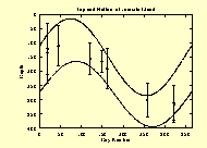
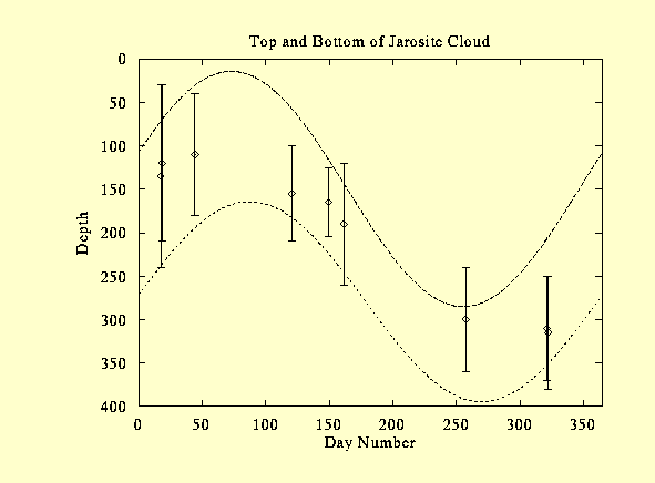
The following figure shows the estimated vertical extent of the jarosite as a function of season. AusProbe data from 1992 to 1997 have been compounded for this plot. The dotted curves indicate annual sinusoidal variations fitted to the vertical extent of the jarosite cloud. These variations are caused by seasonal changes in the density structure of the ocean.
 Click here for a larger plot.
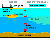
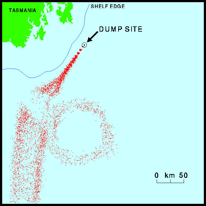
The following figure shows an example of a computer simulation of the ocean dispersal dispersal of jarosite. Each dot represents a fixed quantity of jarosite. The map shows the effect of the passage of a remnant eddy from the East Australian Current.
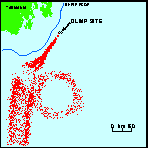 Click here for a larger map.
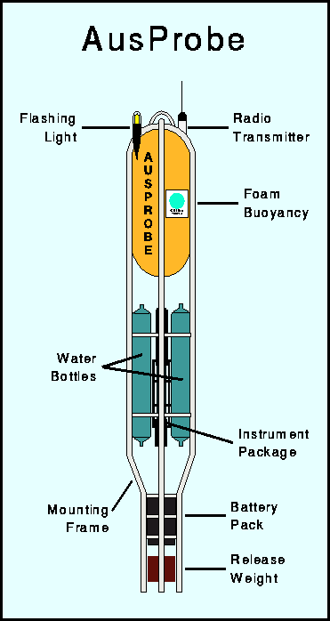
A central component of the instrument package was an Ocean Sensors OS200 CTD which recorded the measured data and controlled all functions of the system. The concentration of suspended matter was inferred from a transmissometer and an optical backscatter sensor (OBS).
Two Niskin bottles were incorporated for water sampling at depths defined by the measured variables. A bottle could, for example, be activated at a prescribed depth, or when the OBS reading exceeded a specific value.
An experiment comprised a free-fall from the surface to a predefined depth, the release of a weight and a return to the surface. The weight release was controlled primarily by the CTD computer, but backed up by a dual system consisting of a mechanical pressure-sensitive device and a corrodible link.
AusProbe was designed for operation from a dumping vessel or a ship of opportunity, with minimum personnel requirements. It operated to a depth of 3000 metres.
AusProbe, originally developed for the study of jarosite dumping at sea, was also used for the observation of the ocean dispersion of mine tailings from Misima Mine, Papua New Guinea.
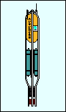 Click here for a larger schematic of AusProbe .